Initial planning for my May Half Term trip shows details as follows
- Sunday 25th Devonport LT 10.03 1.3m; HT 16.12 4.9m. LT 22.30 1.3m
- Monday 26th. HT 04.35 5.0m; LT. 10.59. 1.1m. HT. 17.04. 5.1m
So it's basically spring tides. So I need to bear in mind depth for anchoring overnight at St. Germans and also tidal flows up and down the Tamar and Lynher.
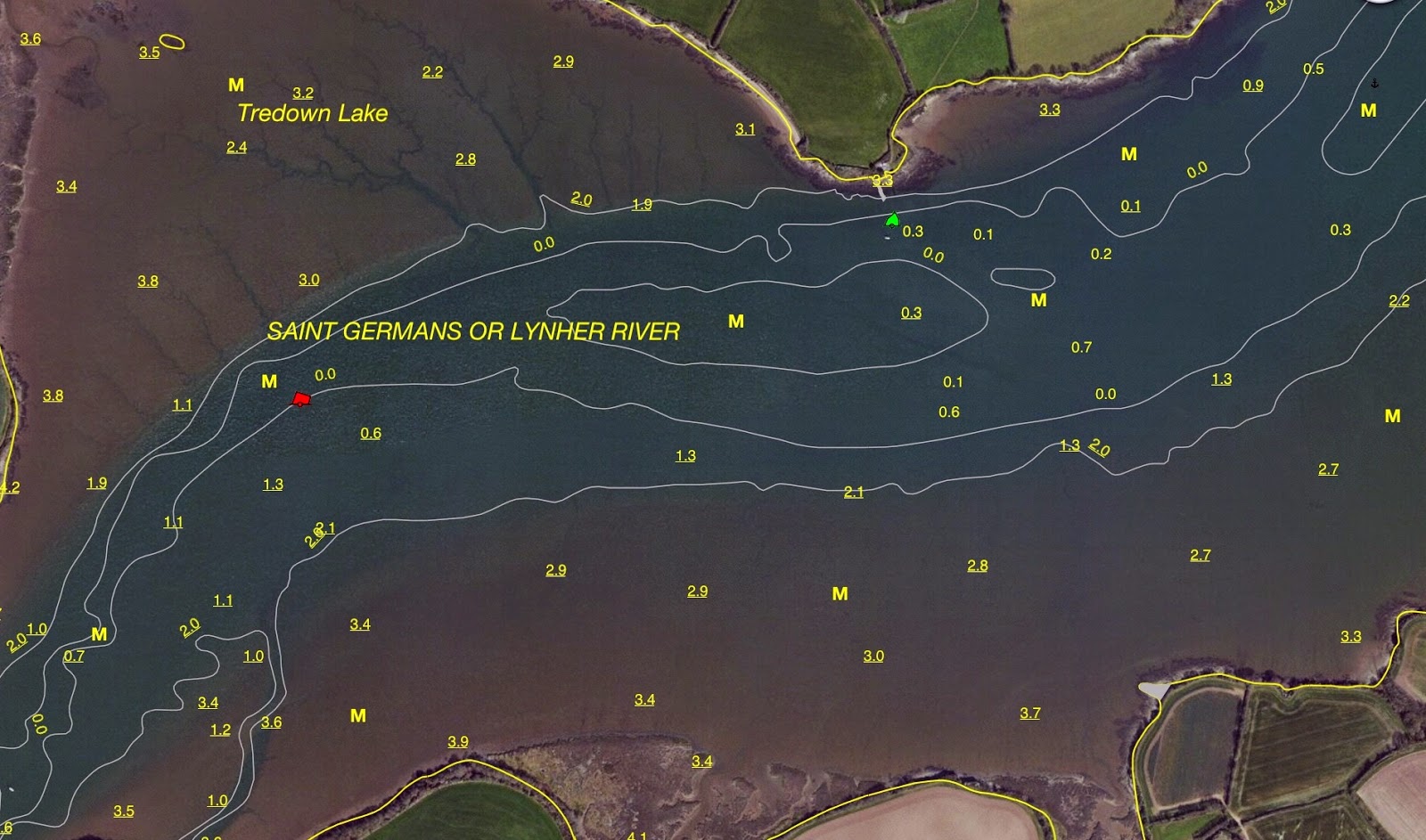
the little port of St Germans
The yellow thing is the large viaduct carrying the Penzance - Paddington railway line
Devonport is off to the south east corner, some 6 miles downstream
St. Germans is very far upriver and I suspect there will be less than 0.5m to anchor in looking at the chart. The chart says 0.7m above chart datum at low water so.........take that away from the 1.3m ......and if I have done this right.....it suggests around 0.60m to anchor in. Take off Arwen's draft which is around 0.30m and yep I suspect it will be grounding overnight.......which is fine. However, as that will be around 10.30 at night I need to be particularly careful in choosing a spot. I suspect I'll be looking for that around 20.30 but will still have approximately 2m of water below me even then.
I have taken the precaution of emailing the St Germans Quay sailing club for some advice and also to see if they have a spare overnight mooring berth.
Pilotage will be fairly straight forward up the Tamar. Turning into the Lynher at the port mark buoy, its then a twisting channel. There are some hazards to watch for. Beggars Island and its shoaling waters to the north of it; Jupiter Point, the naval training base. Need to keep north of HMS Brecon moored mid channel and then it is necessary to hug the northerly channel down to Ince Buoy because that's where the deeper water is and it avoids a rather nasty mid channel sandbank that dries out at low tide. In fact from the Ince buoy upriver, you really need to be 2.5 hrs either side of high tide.

Dandy Hole, the outside of a large meander has deep water at all states of the tide and is my emergency anchorage point. I could anchor fore and aft and it is very sheltered from most directions.
The rest of the river journey is a narrow channel marked by stripped poles either side. An alternative journey is up to boating world. They have a pontoon which I believe is accessible even on low water springs. They also have toilets and that is an alternative destination.
Now all I have to do is start the tidal height calculations, programme my GPS with waypoints etc and I'll be able to furnish you with more details of the planned overnighter next week.
Two weeks to go.
St Germans is to the north west.
The tributary heading north is up to Boating World which is an alternative destination
Boating World very helpfully publish this handy leaflet
Boating World is just up above the yellow shaded viaduct
This is a better aerial view of Boating World, the viaduct and behind that, the Lynher are in the background
Pilotage will be fairly straight forward up the Tamar. Turning into the Lynher at the port mark buoy, its then a twisting channel. There are some hazards to watch for. Beggars Island and its shoaling waters to the north of it; Jupiter Point, the naval training base. Need to keep north of HMS Brecon moored mid channel and then it is necessary to hug the northerly channel down to Ince Buoy because that's where the deeper water is and it avoids a rather nasty mid channel sandbank that dries out at low tide. In fact from the Ince buoy upriver, you really need to be 2.5 hrs either side of high tide.
Beggars Island can be seen in the middle west of the picture above
The jetties in the south of the channel are HMS Jupiter Point, the Navy powerboat training centre

Dandy Hole, the outside of a large meander has deep water at all states of the tide and is my emergency anchorage point. I could anchor fore and aft and it is very sheltered from most directions.
The rest of the river journey is a narrow channel marked by stripped poles either side. An alternative journey is up to boating world. They have a pontoon which I believe is accessible even on low water springs. They also have toilets and that is an alternative destination.
Now all I have to do is start the tidal height calculations, programme my GPS with waypoints etc and I'll be able to furnish you with more details of the planned overnighter next week.
Two weeks to go.


No comments:
Post a Comment