I intended to sail from South Mallard buoy just off Mountbatten breakwater out to the west of the main breakwater via Melampus and New Ground buoys and then out to the Draystone buoy just off Penlee point in Cornwall. From there I was going to head almost due east to OSR south buoy and then north eastwards to West Tinker buoy before turning north to the East Breakwater and Dukes Rock buoy; followed by Dunstone buoy and back to South Mallard. This would have been about 7.5 nm and taken me around 2 – 3hrs. The wind was to be coming from the south west, backing around to the east. The (just down from spring) tide would be running out....with a maximum southerly tidal stream 3 hrs down from HT at around 0.9 kts. The idea was to follow a passage plan prepared the day before; and to practice taking fixes and pinpointing my location on the chart as I went along.
Mt. Batten breakwater which protects the Cattedown to the right hand side
What actually happened was I did it in the reverse order! There is a link that takes you to a short clip of film about the section from south mallard up to the breakwater......it's in the section oppsoite on Arwen videos. Enjoy....and forgive my amateurish filming skills.
In my defence.....the route I originally chose based on the predicted wind directions would have been fine. However, on the day, the wind was blowing from south-south west, (not east) and so I would have been heading straight into the no-go area. I did try – honestly........but at 11.00am – having managed to progress just up to Melampus I admitted defeat and decided to go the backwards way round instead........I hope readers will forgive me this appalling error of pilotship.....but I am still learning all this sea fairing malarkey you know! Now it was an easy decision because I was doing a circuitous route....but if I hadn’t been........then what?
Anyway ......decision made – how did the rest of the day go and how good was my passage plan?
Let’s start with the weather......sunny spells with some cloud; some haze in afternoon reducing visibility at sea; the wind was around force 3 with gusts to force 4; it started SSE, went south; then south east and then kept veering between south east and south throughout much of the day. Sea state was fine inside breakwater but slightly lumpy to the south of it with some nasty rollers coming in on occasions making the boat pitch a lot on some legs of the journey. As always Arwen sailed through it all – she is an amazingly dry boat and copes with some relatively steep pitched rollers with ease.
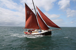
From Dunstone to Duke Rock was a good leg although I needed to put in some long tacks....I am still trying to work out what line to take between waypoints and I guess this comes with experience – Arwen doesn’t sail close to the wind – a close haul is almost 70degrees off the wind........hence several tacks. Several trawlers past by – all giving me waves; then there was a fantastically beautiful Cornish pilot called Curlew who caught up with me and went past gracefully. I tracked her for a while and then she headed off further out towards Rame Head and along to somewhere like Fowey I suspect. Cornish crabber boats are wonderful!
Not the Cornish pilot i saw, but a similar vessel
Just off Duke’s Rock, some inshore lobster pot men waved hello – busy hauling up pots and emptying them – they seemed to be doing well. A tug was moored to one of the big ship mooring floats and behind that was the Fort Rosalie with all her bunting up...obviously just returned from deployment somewhere....the Admiral’s barge went alongside several times. In the meantime, the little red and white Cawsand ferry plied its trade back and forth across the sound.
RFA Fort Rosalie
The very busy little red and white Cawsand ferry
Going between Fort Bovisand and the breakwater was fine – it was an outgoing tide and a tidal stream of 0.9kt helped me shoot through. I carried on a tack towards Bovisand beach......the longer I tacked that direction, the easier it would be to then turn later towards West Tinker buoy.......John and others on the JW yahoo forum group have always said to me, that rather than pinch too close to the wind – go for speed and even if that means longer tacks off where you want to be......and actually it worked. When I turned, I was nicely lined up for West Tinker Buoy on a beam reach.
At this point I was on a reach and with the sail out a bit further; the jib a bit fuller and the mizzen eased slightly, Arwen started to make 4.8kts......punching through lumpy rollers which came in from the south. There was some corkscrew rolling for a time – slightly uncomfortable and then a rattle.....persistent.....the kind of rattle that doesn’t bode well. A clunk and a bronze nut lay on the floor......an emergency hove to....on starboard tack of course..........and a quick investigation.........the nut had come off one of the bronze bolts holding the starboard chain plate in place......um!!!!!!!!!!!!!!!!!
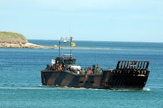
Quick fix and we were on our way – good timing I thought because at this point I was being attacked by three large Royal Marine Landing craft.....their steady thud, thud, thud, engines getting closer.......with fairness the lead boat was very good and realising I was hove to and trying to effect a repair......took gentle avoidance action..........when I looked they were nowhere to be seen....although that heavy thud, thud could be heard within the sea mist that was developing offshore.........lesson learned!
Very similar to the three I encountered coming out of the haze whilst I was hove to...
So far, my estimate timings within Plymouth Sound had not been great....but clear of the breakwater – they were pretty spot on between the buoys – weird that! We scooted across to OSR south; running across the Brittany Ferry, before gybing around Draystone buoy at Penlee point.
My camera battery had run out by now so thanks to Andy on Flick'r for this shot of the Ferry I ran across just off the OSR south buoy
Then it was a long, long, long downwind run across to the knap buoy, west breakwater lighthouse and then down across the sound all the way back to South Mallard buoy.
Draystone buoy off Penlee point on the Western side of Plymouth Sound
And the stat’s? Well total trip length was 12.3nm; average moving speed was 3.4knts; total time sailing was 3 hrs 40mins. What had I calculated previously on the passage plan – around 7.9nm and a travel time of 3 hrs.......so some lessons learned!
1. When passage planning – think carefully about wind direction and what impact it will have on your planned route
2. Give some thought to sea state under different wind speeds and wind directions
3. Before going hove to...check, check and double check there is no one around!
I’m pretty sure there are more lessons but I need to reflect and internalise further.....perhaps the subject of another blog
Steve


Great work. Keep those adventures going.
ReplyDeleteHave you looked into enrolling in a Coastal Navigation Course? I'm sure local coastgaurd or yacht club may run them.
It is good you are taking the time to practice. One day when the for or rain rolls in you may need them.
I practice reading from map to ground and from ground to map.
Also any local orienteering course that gets you reading maps and going on compass bearings etc is all good too.
Cheers
Brian
I'm a professional pilot and some of the navigation is very similar.
Hi Brian
ReplyDeleteI come from a mountaineering background and so many of the principles about map reading/chart reading and compass work are similar. the concept of distance and time etc is also familiar. of course, accounting for leeway (unless its walking back to campsite from pub) is a new one; as is shifting wind patterns.
I'm thinking of enrolling on a day skipper theory course run by RYA but the trouble is they are evening courses during term time and i have about 3 hrs of work each evening ...so it makes it pretty impossible to enroll for a 13 week course......but I am investigating other options.
Thanks for your comments - appreciated
Steve